
Help
Notes:
Android version 1.0. stable, June 2016
Read the warnings carefully HERE
AirTrackPro is an application for general aviation and light aviattion type: ULM, gliding, paragliding, Helicopter, etc ...
The main function is traffic information Ads-b and Flarm on a real-time radar type map.
Continued use of GPS and the Internet can greatly reduce the battery life.
It is recommended to fly with the Smartphone or tablet in charge, or use a Bluetooth GPS external receiver that will greatly reduce the consumption
We have tried during our development to minimize processor workload.
The app requires:
- Access to precise location information (GPS)
- Full data network access
- Android: Permission to allow the App to run in background (keep the phone from sleeping)
*Battery usage: Depending on phone. Up to 5 hours of flight time with the app in
background, slightly less when the app is in foreground.
Data volumes are low, but roaming charges may be engaged
Requires mobile coverage. Experience shows that this works well in mountainous regions,
but may work less well in flat area
Warning: There could be an issue due to handover (cell to cell transit) that can cause a network freeze on some mobile even if the data communication is back;
If you find that the LOC remains red for too long time while the data signal is there: restart the application to recover normal working
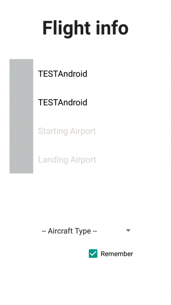
Flight information:
Before launching the tracking please enter the information related to the flight:
- Aircraft Registration: enter your registration (eg F-JSTB) or if you do not have one, enter your nickname (for paragliders)
- ICAO code: the 24bit hexadecimal code identifying the aircraft (eg 394A65); if you do not have it, specify what you want
- Airports (optional): Please indicate the airport departure and arrival (eg LFRN)
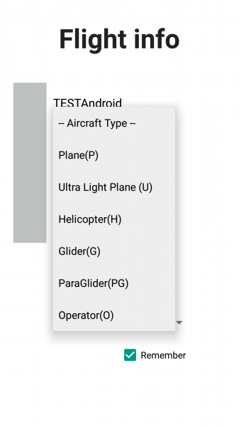
- Aircraft type: Please enter the type
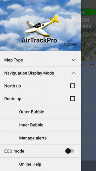
Menu:
To access the menu put you on 'menu' on the left of the map and drag to the right
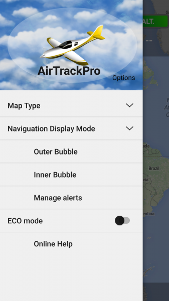
Card type / Rotation type:
For optimal tracking of aircraft in flight, select > Navigation Display Mode> Route up (default)
It is possible to choose another card type (default Relief)
ECO Mode:
If you want to save on your data consumption and stop the mode "screen always on" by default, select that mode
You will lose the detailed map and will end on white background
In case of alarm you will be notified by the phone wake up

- Battery consumption: up to 5 hours flying in Eco mode
- Consumption data: less than 10MB / hours in Eco mode
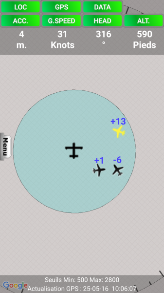
Traffic symbol ADS-B :
![]()
- Reference GPS WGS84 Elevation :differential altitude for calculating the reference Altitude
- Possible Error: up to 200 feet (eg a grounded plane at Nice airport can indicate an elevation of -125 feet!)
- Also indicated if the aircraft is going up or coming down (vertical arrow)
Traffic symbol FLARM :


- Altitude reference for calculating the altitude differential: Elevation above MSL (Note: Not WGS84)
- Also indicated if the aircraft is going up or coming down (vertical arrow)
Traffic symbol AirTrackPro:

- Altitude reference for calculating the altitude differential: Altitude GPS WGS84 or corrected altitude
- The AirTrackPro traffic appear as isosceles triangles (directional) with numbers indicating the vertical separation with your aircraft in hundreds of feet
- Prefix appear if you tap on the traffic as Préfix.Immat
| Type | Préfix |
| Plane | P |
| Hélicopter | H |
| Ultra light plane | U |
| Glider | G |
| Paraglider | PG |
| Opérator | O |
Traffic symbol without bearing:

- The traffic without the "bearing" information are displayed as a black diamond.
Vertical separation:
Above each symbol, a figure indicating the vertical separation thereof with your aircraft is expressed in hundreds of feet
example:
- -12 = 1200 feet below
- +50 = 5000 feet higher
Instant traffic information:
When clicking on any traffic we can view the information related to the aircraft in question: Callsign or Immat (for AirTrackPro), Speed, Heading, Altitude, Relative distance in meters (below)
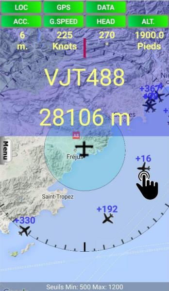
The units:
To change units, click on 'Speed', you could switch from Knots to Km / h
Altitude Calibration :
In flight or on the ground, if you see a difference with your onboard altimeter at QNH wedge, recalibrate the GPS altitude by clicking ALT (Unit only Feet)
GPS is far more accurate in lat long than altitude but dépend on your mobile onboard sensor, precision can be good
Warning: the measured altitude is essential for alerts, reference is GPS altitude (in meters above-the WGS 84 reference ellipsoid - near the QNH) it must be as accurate as possible. To adjust on the read barometric altitude, stalled at QNH
Magnetic North:
The magnetic north is indicated by the red line on the graduated outer perimeter
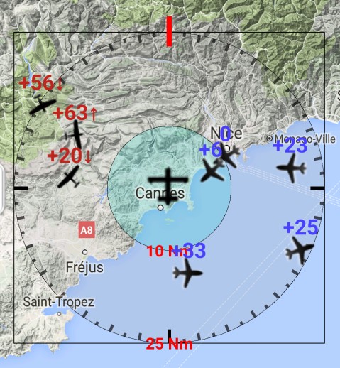
The perimeters:
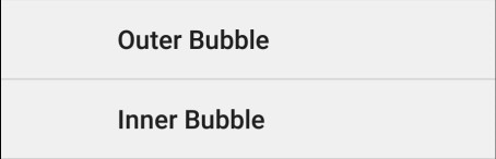
Depending on the type of aircraft, its speed, it is possible to choose your security perimeters: Inner and Outer
From what distance you wish to be notified of potentially dangerous traffic?
In both areas, an algorithm continuously monitors both the differences in altitude but also potentially conflicting trajectories;
Alerts as colors (Yellow or Red) are active (see 'alert threshold' below)
| Outer Bubble | 25 NM by default |
| Inner Bubble | 10 NM by default |
Caution: Do not select an outer perimeter too large, it has no interest in flight and this could add many traffics and will dramatically increase the CPU workload
Aircraft detection limit:
Depending on the aircraft type, location, it is possible to set the maximum altitude detection of the aircraft (in both perimeters)
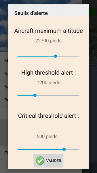
Configurable in the menu> Manage Alerts> Aircraft maximum altitude
|
Altitude ceiling: values [of 3000-40000 feet] |
Caution: Do not select a ceiling below your flight level; eg if you are flying at 6,000 feet in the mountains, do not select a lower altitude ceiling.
The thresholds of vertical separation alerts *:
Depending on the aircraft type, the type of activity, it is possible to define the vertical separation limit thresholds
During the passage of the aircraft within these thresholds and if there is a risk of collision alert is triggered by the change of color and the awakening of the phone if standby
configurable in the menu> Manage alerts
Available in both perimeters and adjustable by the pilot:
|
values [from 500 to 3000 feet ] High threshold alert; 1200 by default |
|
values [from 200 to 500 feet] Critical threshold alert; 500 by default |
Due to potential errors of altitude, it is not possible to choose a critical value below 200 feet.
When flying in plain area, to select a lower ceiling to15,000 feet.
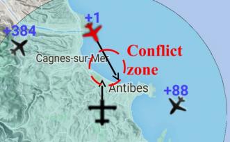
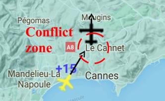
La prédiction des risques de collision:
Un algorithme contrôle en permanence les directions et vitesses et prédit les trajectoires potentiellement conflictuelles avec la votre.
* Il est couplé aux seuils d'alertes, c'est a dire que les couleurs Jaune et Rouge sont actives uniquement en cas de risque de collision, sinon les trafics repassent en noir, même s'ils se situent à l’intérieur des seuils d'altitude sélectionnés.
En aucun cas le pilote bénéficie de consignes de direction vertical type 'Resolution Advisories', il est seulement prévenu d'un trafic potentiellement dangereux par le changement de couleur.
-
When a TA is issued, pilots are instructed to initiate a visual search for the traffic causing the TA. If the traffic is visually acquired, pilots are instructed to maintain visual separation from the traffic
Le phénomène du Gisement Constant:
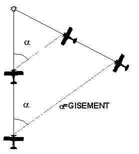
Le rapprochement à gisement constant, caractérisant les trajectoires conflictuelles, et le faible contraste entre un appareil et son environnement peuvent prendre en défaut la vision périphérique surtout sensible au mouvement d'objets fortement contrastés.
L'ergonomie du poste de pilotage et les particularités de l’œil humain peuvent masquer certaines parties d'espace.
La petite taille de l'autre appareil jusqu'à très peu de temps avant la collision rend difficile la détection. De plus son grossissement soudain crée un effet de surprise important.
Enfin la manœuvre d'évitement n'est pas instantanée.
Dans ce cas de figure ou un aéronef et le notre serait dans ce type de trajectoire et "vu" par l'application, une alerte sera normalement générée bien avant que les deux avions ne soient trop proche et le pilote sera alors prévenu, ce qui constitue une sécurité non négligeable
De mème le risque d'abordage à proximité des aérodromes peut être largement diminué dans le cas d'une utilisation massive de l'application.
Les voyants:
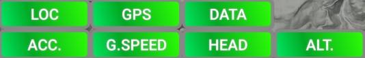

le bouton LOC rouge indique une mauvaise réception du signal GSM et/ou une communication difficile avec le serveur, normalement transitoire
Le fonction radar n'est alors plus assurée et les avions se figent jusqu’à la récupération de la communication
Si le bouton DATA est rouge c'est qu'il n'y a plus de réseau et que vous êtes en zone non couverte ou trop haut (en dehors de la zone de couverture de la cellule)

Le voyant G.SPEED correspond à la vitesse sol (Ground speed)
Si le voyant vitesse clignote en Orange, c'est que votre vitesse sol est inférieure à 30km/h correspondant à:
- une phase de roulage
- un point fixe
- une vitesse air faible type Parapente, Hélicoptère
- un vol face a un vent fort
Important: Si vous êtes au sol et utilisez AirTrackPro, merci de sélectionner le type >Opérateur pour ne pas être signalé en tant que aéronef en vol.
Add a comment